Habitat a Posidonia oceanica, Santa Marina, Salina 2018
Posidonia oceanica beds, Santa Marina, Salina 2018
[Please scroll down for the English version of the text and the suggested citation]
Lunedì 18 Giugno 2018, con maschera e pinne, è stato condotto un monitoraggio a largo di Punta Barone, Santa Marina, Salina nelle Isole Eolie (Figura 1). Un tracciato è stato ottenuto usando un sistema di posizionamento geografico (GPS) Garmin GPmap 62st attaccato ad un galleggiante Beuchat Pluma. Il tracciato ha seguito parte del contorno di una prateria della fanerogama marina Posidonia oceanica (Linnaeus) Delile, 1813 dal lato più vicino alla costa. Per ragioni di sicurezza non è stato possible, al momento del monitoraggio, completare l’intero contorno della prateria. Nonostante questo, il tracciato si è rivelato utile, quando è stato sovrapposto alle immagini satellitari disponibili su Google Earth (Figura 1). Gli habitat a Posidonia sono molto importanti in ambiente marino costiero e la mappatura della loro estensione è un primo fondamentale passo per conoscere lo stato di salute ecologica di queste aree marine di alto valore commerciale.
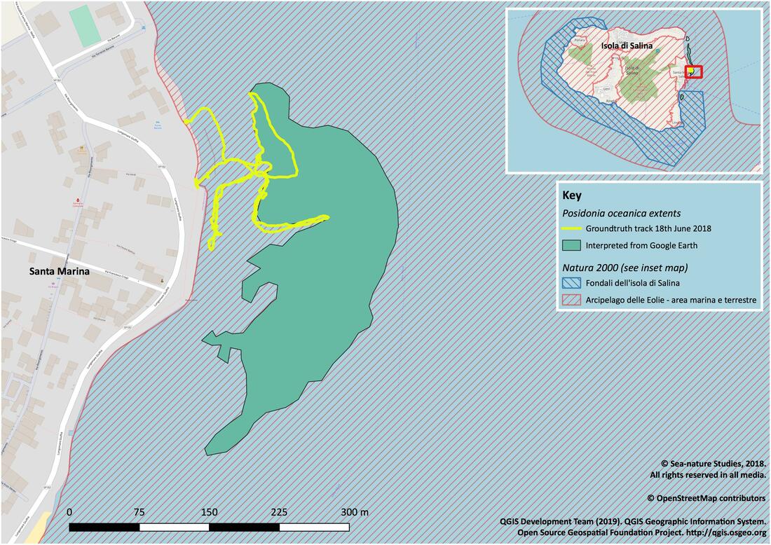
Figura 1. Prima mappatura di habitat a fanerogame dei dati raccolti a largo di Punta Barone, Santa Marina, Salina, Giugno 2018.
Il sito in questione si trova all’interno dell’Arcipelago delle Isole Eolie, un sito europeo protetto da Natura 2000 (Figura 1). Nel tratto di mare vicino alla costa gli habitat a Posidonia si presentavano piuttosto frammentati ed interspaziati da aree sabbiose. Nella zona èstato osservato anche il vermocane (verme di cane o verme di fuoco) Hermodice carunculata (Pallas, 1766), comune abitante di questi habitat. Più a largo lo stesso habitat si presentava più esteso e continuo con occasionali tratti di sabbia. Nella parte più a sud il tracciato segue una fessura stretta della prateria di Posidonia (Figura 1).
Quando il traccato è visualizzato sovrapponendolo alle immagini di Google Earth riprese nel 2014, appare chiaro che questo segue il contorno di una più estesa prateria di P. oceanica. Sulla base delle osservazioni lungo il tracciato è stato possibile interpretare la diversa colorazione del fondale osservato sulle immagini satellitari. Questo ha permesso, con un certo grado di certezza, di tracciare un contorno dell’intera area interpretata come prateria di P. oceanica. Inoltre, aree con simili caratteristiche sono state individuate a nord e a sud del tracciato (Figura 2). I fondali ad est di queste aree scivolano velocemente verso più alte profondità ed è quindi difficile, sulla base di queste sole osservazioni, stimare fino a che profondità si estenda la prateria di P. oceanica. Nel Mediterraneo generalmente questa pianta marina si può trovare fino a profondità di 50m (Dattolo et al., 2013), in base alla penetrazione della luce solare.
L’area individuata a sud era stata precedentemente osservata con maschera e pinne, ma in quella occasione non fu possibile raccogliere dati. L’osservazione diretta, comunque, permette di interpretare l’area come una prateria di P. oceanica (Figura 2). L’area individuata a nord non è stata visitata, per questo è stata colorata in grigio e richiede osservazione sul campo per essere confermata.
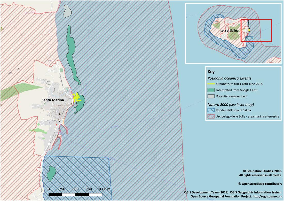
Figura 2. Potenziale habitata a fanerogame nei fondali bassi a largo di Santa Marina, Salina, Giugno 2018.
English text
A snorkelling survey was undertaken on Monday 18th June 2018 from Punta Barone, Santa Marina, Salina in the Eolian archipelago (Figure 1). Using a Garmin GPSmap 62st attached to a Beuchat Pluma float, a track was made by following part of the nearshore boundary of an extensive bed of the seagrass Posidonia oceanica (Linnaeus) Delile, 1813. Although on the day for reasons of safety it was not possible to swim the entire contour of the bed the snapshot was useful especially when viewed subsequently in combination with aerial imagery available via Google Earth (Figure 1). Posidonia habitats are important features in coastal ecosystems and mapping their extents is the first step in gaining an insight into the ecological health of these commercially valuable marine areas.
Figure 1. Initial seagrass habitat map of the ground-truthed location off Punta Barone, Santa Marina, Salina, June 2018. - See above
The location in question lies within the 'Archipelago delle Eolie', a Natura 2000 European protected site (Figure 1). In the nearshore area the Posidonia bed was relatively fragmented, interspersed with patches of bear sediment. In this area a fireworm, Hermodice carunculata (Pallas, 1766) was seen. Further offshore the bed was formed of an almost continual sward with only occasional holes in evidence. On the southerly extent of the snorkel a narrow cut was followed offshore (Figure 1).
When viewed in Google Earth (GE) with imagery from 2014 it was clear that the track followed the edge of a more extensive bed of Posidonia oceanica. Given the ground-truth data the colouration differences seen in the GE imagery became interpretable and a wider boundary could be carefully and conservatively drawn around the entire feature. Furthermore similar areas were distinguishable to the north and south of the ground-truthed area (Figure 2). The seabed drops sharply away to considerable depths on the eastern boundary of these polygons. It is not possible from the current survey work to provide any estimate of the depth to which the P. oceanica beds may extend here. In the Mediterranean more generally this seagrass can be found down to depths of up to 50m, depending on light penetration (Dattolo et al., 2013).
Figure 2. Potential seagrass habitat in the shallow coastal water off Santa Marina, Salina, June 2018. - See above
The patch furthest south was snorkelled but not tracked in a previous year and therefore this enabled the interpretation of this as seagrass habitat (Figure 2). There was less certainty about the area furthest north and therefore this has been marked in grey and will require corroboration from field survey work in the future.
These maps are provisional and in due course it is hoped that further fieldwork will be conducted to confirm boundaries, mark out additional habitats of interest and chart any fluctuations which might be occurring in area. The GE imagery from 2014 enabled these polygons to be drawn but some changes in coastal defence works have occurred since this time. Notably, there is now a substantial rock barrier which extends out from the entrance point of the snorkel at Punta Barone. The track around this new feature is visible in Figure 1.
References:
Dattolo, E., Gu, J., Bayer, P. E., Mazzuca, S., Serra, I. A., Spadafora, A., Bernardo, L., Natali, L., Cavallini, A. and Procaccini, G. (2013). Acclimation to different depths by the marine angiosperm Posidonia oceanica: transcriptomic and proteomic profiles. Frontiers in plant science, 4, 195. doi:10.3389/fpls.2013.00195
Dattolo, E., Gu, J., Bayer, P. E., Mazzuca, S., Serra, I. A., Spadafora, A., Bernardo, L., Natali, L., Cavallini, A. and Procaccini, G. (2013). Acclimation to different depths by the marine angiosperm Posidonia oceanica: transcriptomic and proteomic profiles. Frontiers in plant science, 4, 195. doi:10.3389/fpls.2013.00195
The protected area boundaries used in the maps presented above were sourced from the European Environment Agencies,
Natura 2000 Network Viewer.
Natura 2000 Network Viewer.
This work was entirely unfunded and has no links to any organisation and can be cited as follows:
Barfield, P.D. and Capasso, E. (2019). Habitat a Posidonia oceanica, Santa Marina, Salina 2018. Available at: https://www.seanature.co.uk/posidonia_habitat_salina.html [Accessed INSERT_DATE].
Barfield, P.D. and Capasso, E. (2019). Habitat a Posidonia oceanica, Santa Marina, Salina 2018. Available at: https://www.seanature.co.uk/posidonia_habitat_salina.html [Accessed INSERT_DATE].